Friday, January 30, 2015

Little Yosemite, Sunol Ohlone Regional Wilderness, East Bay

Little Yosemite Loop
Pleasure Rating 1 2 3 4 5
Difficulty Rating 1 2 3 4 5
Click here for Map of Little Yosemite

Why Little Yosemite?
Although the title might be deceiving, Little Yosemite is a fabulous and little known hiking gem for families to explore.  Located in the East Bay's Sunol-Ohlone Regional Wilderness, this 4.5 mile loop is a perfect day hike for those who enjoy beautiful undulating hillsides, rock climbing adventures, geological exploration, and discovery of local flora and fauna.  Although dwarfed in comparison to the real Yosemite Valley, this miniature rock formation area with trickling waterfalls is like its cute baby sister.
The warm late autumn afternoons can be a fun time to visit, but the waterfalls and "no-snake threat" time of winter and spring are probably the best times to visit.  Rattlesnakes and vipers are common and are often found sunning on rocks in summer.  Summer can also pose problems strictly due to sun exposure and heat.  But no matter what the season, it truly is a spectacular day excursion and loads of fun for all.
Let's Get Hiking!
Bring lots of water and plenty of snacks, but lunch is even better because there is a perfect picnic table waiting for you at your destination.  Start by parking at the Old Green Barn visitors center and begin your hike on the Indian Joe Trail.  Indian Joe will intersect with Canyon View Trail.  Start your assent onto Canyon View Trail.  This narrow uphill trail will zigzag across the hillsides, presenting lovely views of the Sunol Ohlone Wilderness.  You might see a few birds, possibly hear the echoing winds rushing through the tiny canyon ahead, and even the mooing of cows in the distance.  The smell of grass and chaparral, and the site of lush countryside that is so wild and free makes you feel like you've escaped from the busy bay area and into a pastoral paradise.
This 1.7 mile stretch to Little Yosemite is mostly a gradual uphill but there are times of straightaway to give your legs some rest.  Remember to take water breaks and breath- every hike deserves a moment to breathe in your surroundings.  Once you descend into the Little Yosemite area, you will see the intersection of Camp Ohlone Road and Canyon View.  Here there is an outhouse and a perfect picnic table.  Or if you prefer to get a little closer to the rocks, pick one to perch on and have your snacks.  After some refueling, go out and explore this pleasant little valley filled with enormous boulders, impressive rock formations carved out over millions of years by the small trickling of this miniature waterfall.  Some might enjoy the more challenging scramble up to the "W Tree" where you can go deeper into the canyon, but for small children, this rocky area is all the fun you'll need.  You could stay here for over an hour just playing around on the lovely cracks and crags of these glacial wonders.


After a fun hikeabout, you can return to the visitors center by double backing on Canyon View Trail, or make it a loop by taking Camp Ohlone Road downhill.  This 1.5- 2 mile stretch will take you down the base of the beautiful hills and wind you back down to the heart of the valley and the parking lot.
This is a perfect family hike, giving just enough challenge and adventure for all to enjoy.  Sunol Ohlone has so much to offer, but Little Yosemite is one of my favorites.


Las Trampas Regional Wilderness, East Bay

Las Trampas Loop to Rocky Ridge

Difficulty Rating 1 2 3 4 5
Pleasure Rating 1 2 3 4 5
Mileage: 4.5 miles
Click Here for Map of Las Trampas Loop

Why Las Trampas?
Located off Interstate 680 and Bollinger Canyon Road in the rolling hillsides of San Ramon, this one of a kind trail offers breathtaking 360 degree views of the entire San Francisco Bay Area, and the adjacent towering monolith of Mount Diablo.  With a challenging assent to the very climax of the East Bay ridge, you can strut upon what is the intersection of three fault lines, an area known by geologists as the Mount Diablo Thrust [to the common man, the Rocky Ridge].  On a cold cloudy day this craggy intersection of hillsides and fault lines with gnarly knobby trees and mysterious rolling fog can conjure images of troll dwellings.  But on a clear crisp and sunny day, you feel like you could just about reach up and touch heaven.  The vistas are spectacular and a must-see for anyone who finds themselves looking for an unparalleled East Bay hike.

 Let's Get Hiking
Pack plenty of water and bring lunch, along with healthy snacks like fruit, trail mix, or granola bars.  My kids love peanut m&ms's mixed in with cashews and raisins.  This is a challenging hike, especially for little ones, so keep energy and spirits bright with plenty of fuel for the journey.  Bollinger Canyon Road dead ends at the park entrance.  Park in the Las Trampas Regional Park lot and if need be, use their toilet facilities here- there will not be any bathrooms on the hike.  The trailhead is located at the northwest corner of the lot where you will immediately begin your 1000 ft assent to the top of the ridge on the Rocky Ridge Road.  It starts as a wide paved road and soon narrows as it turns into a dirt trail.  This initial climb is the toughest and most taxing part of the journey, so pace yourself and allow for breaks.  Take a sip of water and look at the view of Mount Diablo and the Las Trampas range behind you.  It is important to allow children time to rest their legs and catch their breath as to not drain the energy piggy bank on this leg of the hike alone.

Once you have reached the summit you will notice a gate and a short barbed wire fence that separates the Las Trampas Regional Park from land owned by EBMUD.  Technically you are required to have a permit here in order to enter the neighboring trails.  However having hiked these hills many many times, I haven't noticed the enforcement of these rules, nor have I ever crossed paths with any authorities.  So be advised of the rules, but bending them here to get this view is worth it!  Enter through the gate and head west on the trail until you climb another small assent to the top of the Rocky Ridge- you made it!  This is the East Bay summit!
Take a deep breath as you absorb this extraordinary vista.  On a clear day you can see the enormity of San Francisco's Bay Area in all directions- Bay Bridge, San Mateo Bridge, Dumbarton Bridge- Alcatraz, Angel Island, Mount Tamalpais, the east bay and the snakelike Delta that sprawls eastward toward Valejo and Benicia.  The word vista seems inappropriately small to describe this magical view.  This is where I would sit upon a large rock, whip out my delicious lunch or snacks and let the beauty stir your soul.  Allow your food to nourish your body with fuel for the journey back down.  Be proud of your climb, this is a steep assent! What makes this hike extra special is that this vista seems to be smiling at you for about 2 more
miles, as you retreat the original Las Trampas loop trail and continue your journey on the Upper Trail.  Snaking along this resplendent ridge you will continue to enjoy the view as the trail gently undulates along, until finally dropping you back down the eastern side of the ridge.  You will make a left at the Elderberry Trail and loop back around to the park, passing numerous cows and the stables.  The downhill can be steep and hard on the knees at times, so be generous with with the kids and perhaps a piggyback ride or two is in order.

This is a half day hike, so be sure not to get a late start or you will be stuck in the dark with the howls of coyotes haunting you.  With older children who can hike and scramble a whole lot faster, you might be able to time it right to catch the killer sunset atop the Rocky Ridge, but it is not advisable to take that chance with little ones.  It would be far too dangerous in the dark to descend the mountain.
Rocky Ridge and Las Trampas Regional Wilderness are an East Bay treasure and a must-hike for those who love to achieve the incredible summits of the San Francsico Bay.


Wednesday, January 28, 2015

Montara State Beach, Pacifica

Montara State Beach to Gray Whale Cove State Beach

Pleasure Rating: 1 2 3 4 5
Difficulty Rating: 1 2 3 4 5
Mileage: 3 mile round trip 
Click Here for Map of Montara Mountain Trail
Why Montara Beach to Gray Whale Cove?
The famous stretch of California's Hwy 1 between Half Moon Bay and San Francisco is an incredible sight to see.  Most visitors drive in their cars [preferably in a convertible] down the luxurious lanes of coastal highway, enjoying the elegant pacific ever present to the west meeting the dramatic sandy cliffs of the California coast.  This is a bucket list type of drive, so put it on your to-do list immediately.  But to take it a step further and really come into contact with this unique landscape- an even more incredible way to experience this special place is to park the car and go for a little hikeabout!  This perfect mini hike upon the Montara Mountain Trail will offer you a rare chance to witness flora, wildlife, coastline, mountains, and million dollar views in an easy 3 mile roundtrip trek.  

Let's Get Hiking!
Pack a lunch and some treats, maybe even a couple of beers or a bottle of wine to enjoy when you get to the beach.  Bring flip flops and a towel just in case you decide to get wet in the ocean.  Located just south of downtown Pacifica along Hwy 1, park your car at the Montara State Beach parking lot, on the westside.  This is a dirt pull off that you can miss if you are going too fast.  Walk north and you'll see a narrow path that winds for about 50 yards along the cliff and up to the highway.  Carefully cross the busy highway and begin the trail at the sign that says Montara State Beach, McNee Ranch.  This trail will lead you up and over the hills whilst overlooking the majestic Pacific.  For about 1.5 miles you will hug the edge of the mountain as you gaze at the dazzling sun sparkling on the ocean, or perhaps like me, you might spot a breaching whale or two!  
Blooming succulents, poppies and mustard, along with coastal pines envelope your senses.  This unique landscape can feel mysterious and seductive on a foggy day, and on a sunny day it will be cheery and invigorating- no matter what the weather, you can not go wrong.  It is that beautiful.  The trail winds throughout the hillside, so if one wishes to create a more challenging hike, take any one of the spurs that you hit along the trail.  Most of them will all spit you out at the next beach parking lot, which is at Gray Whale Cove State Beach.  Once you reach this parking lot, again, carefully cross Hwy 1 and take the steep ramp, then steep staircase down to the intimate cove. Surrounding you will be the colorful and craggy cliffs and in front of you, the grand Pacific ocean.  
Once you've a comfortable spot on the sandy shores, enjoy your lunch, sip some beverages, and let the kids play in the sand, splash in the waves, collect driftwood, and just be free!  This should feel like a brief escape from reality, a slice of utopia.  This 1/2 mile wide cove is quiet, spacious, gorgeous, and protected from high winds.  Although there are no facilities, it is a fantastic spot to relax and enjoy an afternoon. Two words of caution, the waves can be very powerful and large, so always monitor children closely.  Also, the north end of the beach seems to be a nudist hang out, so use caution when venturing in that direction or you might have a surprise!

Before it gets too close to sunset, head back to Montara State Beach, using the trail from earlier in the reverse direction.  If you time it just right, you'll be back to the parking lot safe and sound before dark.  From the cliffs of Montara State Beach, watch the sun become swallowed by the ocean and witness the sky explode into shades of purple, pink, orange and red. This is paradise!  This breathtaking sunset will complete the perfect ending to a perfect day!


Friday, January 23, 2015

Lands End, San Francisco

Pleasure Rating: 1 2 3 4 5
Difficult Rating: 1 2 3 4 5
Mileage: apx 7 miles roundtrip
Click Here for Map of Lands End Trail

Lands End to China Beach, and Baker Beach
Close your eyes and imagine the fog rolling under the Golden Gate bridge as foamy white waves crash upon the shore.  We can all picture it because the world renowned beauty of this scene is permanently etched in our brains thru movies, television and advertisements.  But you can experience the glory of this unparalleled location all on your own by taking a quick trip into San Francisco for a hike on the Lands End Trail.


Why Lands End?
Located at the southern tip of the mouth of the San Francisco Bay, the Lands End Trail is quite literally where the land comes to an end, the North American continent and the city of San Francisco, at Point Lobos.  This trail allows visitors to encounter the dramatic harmony of nature's glory and man's design- the bay and the infamous Golden Gate.  This is a world class site seeing opportunity, one that should NOT be missed!

Convenient FREE parking (wow!) is available at 680 Point Lobos Ave, above Sutro Baths.  The trail begins right below the parking area and will meander southwest for 1.7 miles hugging the coastline all the way to Eagle Point.  The trail technically ends there but one can continue their hike through the famously lavish Seascape neighborhood of San Francisco and check out China Beach, followed by Baker Beach.  The Golden Gate Bridge, the majestic Pacific, and the elegant Marin Headlands will play peek-a-boo with you, as you zig zag along this special trail.  Available to all levels of ability, this hike can be tailored to fit your desired level of difficulty and will always deliver the beauty one hopes to encounter in this location.  This hike gives one the opportunity to feel the splash of the ocean spray, hear the distant fog horn warning to ships, and see the the Bay Area's most famous landmark in its full glory.
Let's get hiking!
Pack a lunch, bring water and DO NOT FORGET YOUR CAMERA!  If you have a dog, bring him too, as dogs are allowed so long as you pick up after them. As is typical for the Northern California coastline, weather is inclement so be prepared with layers of clothing.  You may be warm when hiking, but sit down on the beach as the fog rolls in and you'll be chattering your teeth in no time!

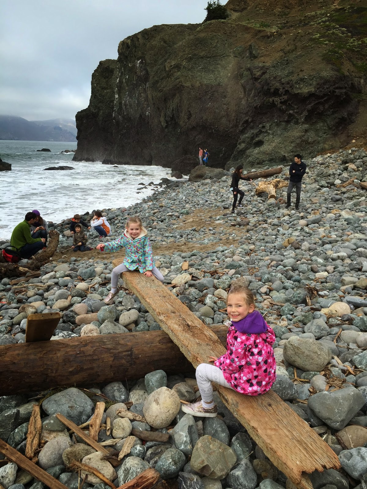
Start your hike at the parking lot at Lands End where there is a memorial to the USS San Francisco- a WWII cruiser from the Battle of Guadalcanal with an adjacent overlook.  Then descend the steep staircase to the trail.  Begin the Lands End Trail hike by turning right, toward the Golden Gate.  About .5 miles in you will have the opportunity to make a slight detour to the rugged cove at Eagle Point Labyrinth.  This is a great chance to actually feel the rocks and see where the waves crash upon the rugged cliffs.  This rocky little beach is a fun place for kids to do some rock climbing, collecting drift wood art, and exploring.  These kids discovered a makeshift teeter totter!


After a break at this tiny cove, ascend back onto the trail and continue to hike until you reach the final point of the trail at Eagle Point.  At this point I suggest taking some pictures and a rest.  For those who want to return to their cars and keep it easy, you can now turn around and double back to the parking lot.   

But for those who wish to continue your hike to China Beach and then Baker Beach, do so by entering the Seascape neighborhood.  Enjoy this unique opportunity to see the lifestyles of the rich and famous!  These multi-million dollar homes are owned by some of the wealthiest people in the world, from actors to dot com tycoons.  The architectural and landscaping details, along with the refined and tasteful decor is truly a stunning site to see, almost as beautiful as the natural elements that surround them!
Make a left onto El Camino Del Mar, and continue until you wind down to Seacliff Ave.  Make another left and you will dead end at China Beach.
China Beach is the perfect place to take a lunch break and utilize the public restrooms.  This private and hidden little gem might be sprinkled with locals, but offers a truly quiet respite from the busy trail, not to mention stellar views of the ocean, the adjacent headlands, and of course, the Golden Gate.  Whilst relaxing at China Beach, the kids can splash in the waves, watch fishermen catching crabs right on the beach, and climb upon the small rock formations.  Enjoy your lunch and take in the evocative landscape- this is a special place.

For the ambitious hiker, continue along your journey all the way to Baker Beach by returning to Seacliff Ave and make a left.  After about .6 miles make a left at 25th Ave and meander a short distance down this dead end street until you reach a beach access.  


Baker Beach is a world class scenic location.  With the Golden Gate towering above, the long stretch of soft sandy beach, and the thunderous waves crashing, you feel as if you've escaped into a little piece of heaven.  Here you can pause to watch the enormous cargo ships rolling under the bridge, catch a glimpse of the sunset, or just take a nap!  Walk to the very end of the beach and climb upon the rock formations that jut out under the bridge.  Do beware that "nudes" frequent this end of the beach, so don't be surprised if you see some shivering nakies.  At low tide, you can walk upon the tide pools to see the kaleidoscope of sea anenomes, urchins, starfish, mussels, clams, and crabs.
This is a special place, and Baker Beach is worth a day visit in and of itself.

After the sun has set on your perfect encounter with Lands End and the surrounding stunning beaches, it's time to walk your butt all the way back to your car, or better yet, have your significant other go fetch it!  Another alternative and added benefit to hiking in a major city is that if you want to make it a one way journey, there is a variety of transportation options to choose from: Uber, Lift, Taxi, and public transit can either take you home, to your hotel, or back to your parked vehicle.  You will be exhausted after this stunning hikeabout, and overwhelmed by all this beauty, so plan on ordering take-out and hitting the hay!

Sunol Ohlone Regional Wilderness, East Bay

Pleasure Rating:   1 2 3 4 5
Difficulty Rating:  1 2 3 4 5
Mileage: est 4 mile loop 
Click Here for Map of Cave Rocks Loop

Sunol Ohlone Regional Wilderness, East Bay

Cave Rocks

Why Sunol Ohlone?
Sunday and sunny is a recipe for a smile; but add in a gorgeous local hike, and now you have bliss.  This was my Sunday whilst exploring the Sunol Ohlone Regional Wilderness with my family last weekend- bliss.
Located just about 10 minutes off of I-680 in Sunol, this East Bay Regional Park is convenient and expansive, offering hiking trails, activities, and services to suit any visitor.  Whether you crave a cozy creekside picnic with the backside of Mission Peak in view, or a bit of trotting around on horseback, or yearn for a walk-about in the rolling hillsides, you will find it here.  Perhaps like me, you dream of exploring the numerous rock formations of Little Yosemite and Cave Rocks while trekking on the many miles of hiking trails- this park literally has it all.

We have visited this park frequently, but no matter how many times we go, it just never disappoints.  This particularly sunny Sunday in mid-January, we decided to explore the Cave Rocks area.  Winter is the probably the best time to take this particular hike because the hillsides are a dazzling emerald green color, its not too hot, and best of all, the local “fauna” is hibernating.  As is true in most of the Western United States during the dry hot months of summer, rattlesnakes and tarantulas are commonly found hiding in the shadows of these rocks, (Yikes!) but are extremely uncommon in winter.

Here is my recommendation for a great day hike in Sunol Ohlone Regional Wilderness:
For a map of this park visit: http://www.ebparks.org/parks/ohlone#trailmap

What to bring:
Pack a backpack full of water, snacks, lunch; and to keep spirits high, throw in some treats.  I bring lollipops or bite sized chocolates.  Make sure you have comfortable hiking shoes and some layers to peel off or put back on.  You might be warm on the hike up, but the easy downhill can spur on a chill as your sweat combines with the wind.

Let's Get Hiking!
Starting from the parking lot at the Sunol Visitor Center, take the Indian Joe Nature Trail, then hop scotch on rocks over the quiet Indian Joe Creek, and begin the 2-mile trek toward Cave Rocks on the Indian Joe Creek Trail, appropriately named because it follows the creekbed throughout the hike.  The miniature waterfalls and trickling water sounds are seen and heard throughout this first leg of the hike, which adds to the quaint ambiance and beauty of the experience.  The steady uphill climb might require frequent water breaks and a quick rest, but won’t present a daunting challenge.  Enjoy the vistas, stop to smell the chaparral bushes in winter bloom, and listen to the sounds of swallows and the babbling brook.  You might even spot some deer or hear the moo of cows in the distance.  It is all part of the experience!  Soon you will arrive at the main attraction, Cave Rocks.

This impressive collection rocks, some reaching 50 feet tall, harken a feeling of being in a remote area of the high Sierras.  The sharp jagged edges, towering heights, and deep crevices are not for the faint of heart.  For those who don’t mind some adventure and are not fearful of heights, Cave Rocks presents a fun opportunity to climb and jump, scale and scramble around.  Be EXTREMELY careful with small children, as there are numerous hazards, drop offs, loose rocks and cracks.  It’s not a huge area, but big enough to play around for a while before everyone needs a lunch break. 


For lunch, continue the assent for about .25-mile until the trail veers to the left and intersects with Cave Rocks Road.  You might spot a small pond on the right filled with timid turtles and playful salamanders.  The kids will love observing the abundant water creatures. Follow this fire lane dirt trail another .25-mile along until you reach High Valley Camp Trail where a beautiful old barn with a perfect picnic area and bathrooms (albeit outhouses), and a water spigot await you.  

This is a great time to rest, eat your sandwiches, take a bathroom break, and enjoy the view.  Deep below is the Sunol Valley, across is the backside of Mission Peak, and behind you is the frontside of Flag Hill- everywhere you look is beauty.  


From the High Valley Camp picnic area, take the Hayfield Road trail to descend back toward the visitor center.  This roughly 2-mile downhill is fast and easy, and provides scenic vistas of the valley below and the surrounding hillsides.
For a day in the wilderness, a bit of adventure, and a hike that is sure to please, 
visit Sunol Ohlone Regional Wilderness.